
London LOOP | Section 18: Enfield Lock to Chingford

If you are looking for car-free adventures in and around Enfield, then why not explore one of the many popular walking trails local to you. There are plenty of options in Enfield, like Section 18 of the London LOOP which starts at Enfield Lock and finishes in Chingford.
The London LOOP (London Outer Orbital Path) is a circular walking route between Erith and Purfleet. It is a 150 mile (242km) walk that is divided into 24 sections and takes walkers through parks, woods and countryside locations around the edge of Outer London.
The route is split into three main groups: South London (the blue route), north-west London (the green route) and north-east London (the yellow route). The route is well marked with signposts and markers. You might have come across the London LOOP logo on local walking trails - it is flying kestrel.
Section 18 of the London LOOP | Enfield Lock to Chingford
The past weekend we decided to explore Section 18 of the London LOOP and it was fantastic. The route is a mix of relatively flat paths, some paved paths and some unmade sections with gradients (mainly the climb to Sewardstone Hills and to Hawk Wood). There are a few fence stiles to cross too. But it is a great trail to blow the cobwebs away and enjoy the green spaces in Enfield.
Note: Only a part of the route is suitable for prams/buggies or the less mobile. And this is the section from Enfield Lock station to the Swan and Pike Pool.
Section 18 of the London LOOP covers a distance of 4 miles (6.5kms). It starts at Enfield Lock (the nearest public transport is Enfield Lock Station) and ends at Chingford (the nearest public transport is Enfield Lock Station). The main sights along this route are Enfield Lock, Sewardstone Marsh Nature Reserve, King George V Reservoir, Gilwell Park (which houses the Scout Headquarters), Yardley Woods and Epping Forest.
Section 18 starts at the footbridge over Turkey Brook (the point where Section 17 of the London Loop ends) near Enfield Lock station. If you consider Enfield Lock station as a landmark point, then once you exit the station, turn right and then take the first right into Bradley Road. Walk to the end of this road and you arrive at Turkey Brook.

From here you turn left (before the bridge) and continue on the path. You will reach Newbury Avenue. Cross the road and keep walking along the brook. You will shortly arrive near the playing fields of the Prince of Wales Primary School. Here the path diverges into two. Keep on the path on the right and cross the bridge over Mollison Avenue.

Once you have crossed the bridge, the path will lead you to Enfield Lock.

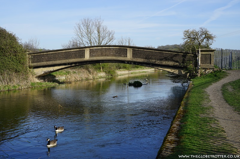
Cross the River Lee Navigation and immediately turn right onto the towpath. Walk along the path and you will reach Swan and Pike Pool.

Continue ahead, go across the car park and you will reach a footpath. There is a signboard here with directions for the London LOOP and Sewardstone Marsh. Follow this path. Ignore the first bridge that you come across (this takes you to Enfield Island Village). Keep walking alongside the river and you will reach the next bridge. You will notice the eel screening mechanism that was constructed here a few years back.

Cross the bridge and continue ahead. On this stretch of Section 18, you might spot horses grazing in the pasture along the River Lea.

Continue ahead and you will come across the next bridge a short distance away.
Once you have crossed the second bridge, you will arrive at the Cattlegate Foot Bridge. There are some lovely views of River Lea and the surroundings to be enjoyed from the bridge.
Cross the bridge and you arrive in Sewardstone Marsh Nature Reserve.

Stay on the wide path and continue walking straight along the route. You will eventually arrive at a metal barrier that will lead to Goodwin Close. Continue walking and you emerge on Sewardstone Road. Turn right here, and as you arrive at Sewardstone Close, cross the road. Here you will come across the first stile on the route. Cross it and cut through diagonally across the field.
We walked this route on a Sunday and there was a car boot sale happening on the field. So, we couldn't cut through the field. There was a way marked for pedestrians and we followed that. At the end of the field, you will find some felled tree stumps and a narrow ridge of earth/soil. There was a gap between the ridges and we continued ahead through the gap. I am not sure if the area is always like this or if it was a temporary disruption due to some work going on there. But this is the route. Continue ahead and you are in Daws Hill Park.
At this point (let's call it Point X), you will see the path bifurcating into two.

The path on the right is the one mentioned on the London LOOP map and it will take you straight up the tree-covered hill. There are beautiful views of the two reservoirs (King George V Reservoir and the William Girling Reservoir) from this point (let's call it Point Y).

If you opt to take the path on the left at Point X, it will also take you up to Daws Hill. This path is unmade. But as you reach the top, you will love the beautiful views you are afforded from here. We spent some time here, enjoying the views and then walked through a wooded area to reach Point Y.


At Point Y, there is a London LOOP waymaker. Follow the direction it indicates. There are a few turns to take and a few more stiles to cross. We found this section of the route a bit confusing. Either we missed the waymarkers or they were no longer in place. Luckily we had the Section 18 map on our phone and we finally managed to find our way. The path eventually leads onto a track leading to Bury Road. Once you are on this track, turn left. Continue walking and you will reach Gilwell Lane. Turn right and continue walking. You will arrive at the Scout Association Headquarters in Gilwell Park.

Turn left and continue on the unmade path past the vehicle barrier. Please note that this path is a 'Bridleway' and you may have to share the path with horse riders. A little ahead, the path forks into two. Continue walking on the path on the right.

Halfway down the path, you will notice a waymarker, follow it and you will come out onto Yardley Hill (photo below). Yardley Hill is a great spot. On a clear day, you can spot some of London's major landmarks from here.

Continue on the hilly path all the way down to the bottom of the valley.

Here you will have to cross the intersection and continue on the grassy track on the other side. This path takes you through Hawk Wood onto Bury Road. Cross the road and turn right joining the path that runs parallel to Bury Road.

Continue on this path and you will reach the Chingford Plain Cark Park. A little further is the Chingford Golf Course Club House and cafe which is the end of Section 18 of the London LOOP.

Note: Chingford rail and bus station are a short walk from the endpoint of Section 18.
I hope this post inspires you to head out and explore Section 18 of the London LOOP. If you want to explore other sections of the London LOOP, you can find more information here.
Post a Comment